

Ein Lior Mayan
From Zissil
(Difference between revisions)
| Line 10: | Line 10: | ||
}} | }} | ||
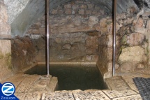
| − | '''Mayan Ein Lior''' is located in Ein Zetim alongside the 8900 road heading from [[Safed|Tzfat]] towards the Ein Zetim intersection. It is often used as a Mikva on the way to [[Kivrei-Tzadikim|Kevrei Tzadikim]], especially [[Rabbi Yehuda bar Ilai|Rebbe Yehuda bar Iloy]] who's tomb is located further down the road. Mayan Ein Lior was renovated in memory of Lior Dahan who drowned in the Mediterranean Sea off the cost of Caesarea, by his friends. The basin of the Mayan built for immersion is roughly 3x5 meters wide and 100 cm deep. | + | '''Mayan Ein Lior''' is located in Ein Zetim alongside the 8900 road heading from [[Safed|Tzfat]] towards the Ein Zetim intersection. It is often used as a Mikva on the way to [[Kivrei-Tzadikim|Kevrei Tzadikim]], especially [[Rabbi Yehuda bar Ilai|Rebbe Yehuda bar Iloy]] who's tomb is located further down the road. Mayan Ein Lior was renovated in memory of Lior Dahan who drowned in the Mediterranean Sea off the cost of Caesarea, by his friends. The basin of the Mayan built for immersion is roughly 3x5 meters wide and 100 cm deep. It can be assumed the stream was used historically by residents of Ein Zeitim for ritual immersions and as a source of water. |
=== Directions === | === Directions === | ||
Revision as of 17:04, 9 June 2013
 | |
| Hebrew: | |
|---|---|
| מעיין עין ליאור | |
| Location: | |
| Ein Zeitim | |
| Description: | |
| Stream used as a Mikva on the side of the 8900 near Tzfat. |
Mayan Ein Lior is located in Ein Zetim alongside the 8900 road heading from Tzfat towards the Ein Zetim intersection. It is often used as a Mikva on the way to Kevrei Tzadikim, especially Rebbe Yehuda bar Iloy who's tomb is located further down the road. Mayan Ein Lior was renovated in memory of Lior Dahan who drowned in the Mediterranean Sea off the cost of Caesarea, by his friends. The basin of the Mayan built for immersion is roughly 3x5 meters wide and 100 cm deep. It can be assumed the stream was used historically by residents of Ein Zeitim for ritual immersions and as a source of water.
Directions
Geographic Coordinates
- Latitude: 32.977013
- Longitude: 35.497782
More Photos
- Mayan Ein Lior Photo Gallery